SOURCE: Report on Flood Control, Frankford Creek, City of Philadelphia, Pennsylvania. Knappen Engineering Company, 280 Madison Avenue, New York 16, N.Y. October 1947. Pages 18-23
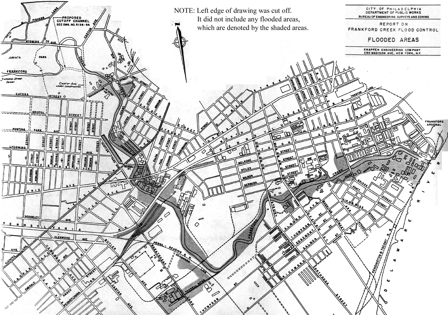
A map showing frequently flooded areas along Frankford Creek, from 1947 Report Click photo for larger image (520 Kb)
Early Floods.
With steep narrow valleys and a drop in elevation of 400 feet from the headwaters to the mouth, it is probable that Frankford Creek was always subject to sudden flash floods. Early reports indicate this to be the case. The 1882 report of the Chief of Engineers, U. S. Army, has already been quoted with regard to damage by "the bursting of dams". The same source in 1884 mentioned that the creek was subject to sudden and violent floods. The report published in 1913 as House Document 1260, 62nd Congress, 3d Session, states that "the creek is subject to floods of considerable height at and above the head of navigation."
For this report more definite information has been pieced together from records of the Bureau of Engineering of the City of Philadelphia, from [page 19] newspaper accounts of flood damage and from high water marks and other records preserved by property owners along the creek. The earliest flood for which there is a definite date was on September 15, 1904. No flood heights have been preserved for the flood, but rainfall records indicate that perhaps it was greater than any flood of recent years. Residents along the edge of Juniata Park recall a damaging flood in 1906, probably in June, which ruined the gardens of a nursery at Fisher's Lane. Floods of sufficient importance to be mentioned in records occurred on August 9, 1916, and August 12, 1918.
Recent Floods. --The first flood for which we have found a known elevation is that of July 23, 1927. Newspaper accounts say that it was the greatest flood in the previous ten years. From records of flood heights, it has been determined that the 1927 flood was exceeded at least 10 times in the subsequent 20 year period, indicating an abrupt increase in flood frequency in recent years.
Property owners along the creek were inconvenienced by floods from time to time prior to 1930, but beginning with the flood of June 26, 1930, they experienced a long series of disastrous inundations. In the summer of 1931 there were record breaking floods on July 10, July 14 and August 10. Floodmarks are available only for the flood of July 14. That flood had an estimated discharge of 6,500 cubic feet per second, and is quite certainly the greatest flood in the past 30 years. The second largest flood came on August 18, 1932, with a discharge of 5,800 cubic feet per second. In the 17 year period 1930-46, inclusive, only the three years 1940, 1942 and 1944 appear to have passed without flood damage. Because there has been no continuous record of the variations in stage of the creek, there may be some [page 20] omissions in the record as pieced together but the following chronological list of flood rises is believed to be quite complete:
July 23, 1927;
Sept. 8, 1929
June 26,1930
July 10, 1931, July 14, 1931, two articles (766 and 664 Kb), and Aug. 10, 1931 (247 Kb)
March 28, 1932, July 22, 1932 (229 Kb) and
Aug. 18,1932
May 24,1933 and Aug. 23, 1933
June 30, 1935, July 9, 1935 and Sept. 6,1935
Jan. 9, 1936
Aug. 26, 1937
July 23, 1938 and Sept. 23, 1938
July 27, 1939
July 28,1941
1943--Floods in May, June, July and October
July 5, 1945
1946--Floods in May, June and July
Analysis of the above-listed flood occurrences indicates that discharges of various magnitudes can be expected with the probable frequency shown in the following table:
[##///## = Discharge in cubic feet per second///Average frequency in recurence in years]
The dates mentioned in the preceding paragraphs [page 21] indicate that the greatest floods on Frankford Creek have not occurred in the spring and fall as on large rivers like the Delaware, but have occurred in the summer months as a result of intense thunderstorms or so-called cloudbursts. Thunderstorms are generally localized and may cover an area only a few miles in length and breadth. For example, summer floods have occurred on Frankford Creek when little or no rainfall was recorded in downtown Philadelphia. Local storms that moved across the drainage area in a direction from northwest to southeast appear to have caused the most severe floods. Some of the floods have been caused by general rains brought in by intense tropical storms or hurricanes. These latter storms occur in the summer or early fall. The present development of the Frankford Creek drainage area has undoubtedly changed the characteristics of the floods. Observations in the field and theoretical studies indicate that in time of flood the creek rises very rapidly, possibly 10 feet in an hour, and that it reaches an initial peak in one to two hours. This type of flash flooding is caused by the runoff from about 15 square miles of sewered area above Juniata. Park. The flood runoff from the remaining drainage area in Montgomery County is slower and causes a second and lower peak about 3 hours later than the first peak.
Although the construction of buildings, paved streets and storm sewers tends to increase the rapidity of runoff and the frequency of minor floods, it has certain advantages insofar as flood control for the creek is concerned. For example, it is not practicable from an engineering standpoint or justifiable from an economic standpoint to design sewer inlets and discharge lines to pass immediately the peak runoff from very rare storms. Following such storms the rate of discharge from a sewered area is limited by the capacity of the sewer system and as a result temporary ponding may occur in streets and at low points. Therefore, the peak rate of runoff from a developed area [page 22] may be less than from an equivalent undeveloped area. This condition exists in the lower portion of the Frankford Creek watershed where the total ultimate capacity of the sewer system will limit the peak discharge to 10,400 cfs. This is a large discharge compared with the greatest flood of record (6,500 cubic feet per second) but may ultimately occur.
A flood on the creek may result from contributions of runoff from both the City sewered area and the County suburban area but there is little chance of both areas contributing maximum discharges in coincidence. There is also little chance, that even if a severe storm centered on the suburban area, the resulting peak discharge from that area alone would exceed the maximum recorded flood on Frankford Creek. The reason for the latter statement is that there are three street bridges (Adams Avenue, Rising Sun Avenue, and Fisher's Lane) and one railroad culvert (Reading Railroad) with moderate sized waterway openings that would tend to throttle discharges of more than about 5,000 cubic feet per second. The throttling action of the bridges would cause ponding in the park areas upstream, further modifying the flood runoff and delaying the time of travel.
The above discussion indicates that, although the lower reaches of Frankford Creek will continue to have floods in excess of the present channel capacity, there are certain features of the present upstream development that act to reduce overwhelming floods such as can occur on natural areas of equivalent size.
Tidal Inundation.
High tides or a combination of high tides and flood flows in the Delaware River have several times caused flooding in the lower reaches of Frankford Creek below Orthodox Street. A combination of high tides and runoff from Frankford Creek have caused flooding between Orthodox Street and Frankford Avenue.
[page 23] The highest tide of record occurred on August 24, 1933, at the time of a tropical hurricane. The crest of this tide at the mouth of the creek was 5.5 feet above normal high tide. The rains accompanying the hurricane caused one of the highest known floods in the upper reaches of Frankford Creek on August 23. It is estimated that the peak of the flood in the creek occurred when the tide was 3 feet above normal high tide. The flooding from the combination of causes was probably the worst ever experienced for a distance of about 2 miles above the mouth of the creek.
Two other periods of flooding at the mouth of Frankford Creek occurred at times of abnormal tides in combination with floods in the Delaware River. The peaks of these two floods occurred on October 11, 1903, and March 19-21, 1936, and reached elevations about 4 feet above normal high tide. Normally there is no slope in the Delaware River at the mouth of Frankford Creek, but there is appreciable slope during very high floods such as those mentioned above. Because of this absence of slope, the elevation of the tide at the mouth of the creek is normally the same as at Chestnut Street in downtown Philadelphia. The tide at Frankford Creek lags the tide at Chestnut Street by about half an hour.
Any plan of flood protection for the creek must take into account tidal effects and their combination with flood runoff in the upper creek.